Floods and Mass Wasting
Landslides in the UK
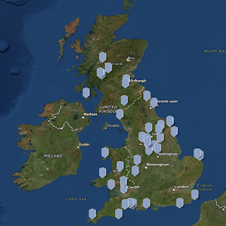
On an island with a high population and large quantity of mountains, landslides are bound to cause destruction of property and loss of lives. The UK is no exception to that. In fact, 18,000 landslides have been documented since the 1970’s with over 100 lives taken from these natural disasters. Each dot on the map below is a documented landslide that is being updated with every new occurrence by the British Geological Survey National Landslide Database.

Why do landslides occur? Landslides can occur with different materials, in different directions, at different speeds, and with varies degrees of destruction. The diagram below can help you differentiate between the different kinds of landslides present all over the world. In order to study the differences between all of these landslides, The BGS National Landslide Database records:
- age
- damage caused
- full bibliographic reference
- location
- movement date
- name
- size/dimensions
- trigger
- type

Preventative measures
It’s not always clear whether or not an area will be cause for concern because apart from gravity’s role on landslides, the largely unpredictable weather can make dangerous areas into hazard zones.
In the map below, you can see the multiple occurrences where some kind of landslide has taken place in the UK. These areas are case studies that are being closely monitored by the BGS National Landslide Database. Their hope is to be able to find relationships between weather, human patterns that may trigger landslides, and many other factors, in order to better understand how and when future landslides may occur.
Great research!!-Congratulations.
ReplyDelete